Turn-by-turn navigation
Once you tap Go, the map tilts, locks onto you, and a card appears at the top with your next turn. Everything else on screen gets out of the way after ten seconds. Here’s what each part is telling you.
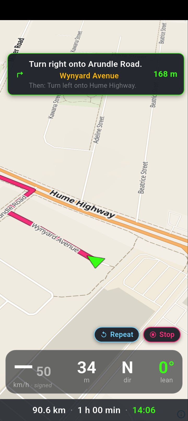
The turn card sits at the top: the instruction, the road you’re on underneath it in amber, the distance to the turn on the right in green, and the Then: line when the next turn is close behind.
Along the bottom, the strip shows how far is left and what time you’ll get there. The four readouts sit just above it.
The turn card
Four things live in that card, and each one can be absent:
- The instruction — the turn itself. While the app is working out a new route this is replaced by Recalculating… and a small spinner. Before the first GPS fix lands you may briefly see Navigating….
- The road name, centred underneath in amber. This is the road the current leg of your route runs along. It’s blank if the route data doesn’t name it.
- The next turn after this one, shown as Then: … in small grey text. It only appears when that turn is within 80 metres of this one — the two-in-a-row case where you need to know both before you commit to the first.
- The distance to the turn, in green, counting down.
If the instruction — or the Then: line under it — contains a U-turn, the card’s border changes from green to red and thickens. NavForge works hard to avoid handing you a U-turn, so when you see that border, read the card properly before you act on it.
Distance and arrival time
The bottom strip shows two numbers: how far you have left, and the clock time you should arrive. Both update as you ride.
The arrival time is worked out from your rolling average speed over roughly the last ten GPS readings — or the average speed the routing engine expected for the whole route, whichever is higher. That second half matters: crawling through one set of lights won’t blow your arrival time out by an hour. If you’re stopped and there’s no usable estimate, the time is left blank rather than shown as something invented.
Distance and speed follow whatever you’ve set under Units. Metric gives you metres under a kilometre, then kilometres; imperial gives you yards then miles.
Why the buttons disappear
Ten seconds after navigation starts — and ten seconds after your last tap — the side buttons and the Detour pill fade out over about a third of a second. At the same time the turn card widens: in portrait it stretches almost to the right edge, in landscape it goes from around 45% of the screen to 60%. Bigger text, less clutter, more map.
Tap anywhere on the map and everything comes back, and the ten-second countdown starts again.
The turn card, the bottom distance-and-time strip, and the Stop pill stay put the whole time. You never have to wake the screen up to see where you’re going or to end the ride.
How the map moves
The view tilts to 45° and turns with you. The camera doesn’t sit on top of your position — it’s pushed ahead of you, from about 80 metres at walking pace out to 400 metres at highway speed, so you’re near the bottom of the screen with the road ahead filling the rest.
Zoom follows speed too: close in when you’re slow, further out as you pick up. It zooms out the instant you accelerate, but only zooms back in after you’ve been slower for three seconds — otherwise it would breathe in and out at every set of lights.
Your arrow is snapped onto the route line whenever you’re within 30 metres of it, which keeps it running cleanly down the road rather than wandering with GPS noise. Past 30 metres the snap is dropped and you see your raw position — that’s also roughly the point where the app starts thinking about a reroute.
Reading the whole list of turns
The card shows you one turn at a time. For the rest of them — to see whether the next three are close together, or which road you come out on — open the menu and tap Turn-by-turn.
It’s there whenever a route exists, not only while you’re navigating: plan a route and the row appears, alongside Elevation Profile. Before you set off the heading reads Turn-by-turn; once you’re riding it changes to Turns remaining and carries the count and the distance still to go — Turns remaining · 11 turns · 20.8 km.
While riding, the list opens at the turn you’re approaching rather than the start of the route, so you don’t scroll past what you’ve already ridden. Each row gives the instruction and how far ahead it is. The last row is your destination.
If the route changes while the list is open, the list changes with it. It shows the route you are actually on rather than the one you originally previewed — which matters most in exactly the situation where you’d reach for it.
Getting to it while moving is fiddly, and worth knowing before you try. The on-screen buttons fade after ten seconds, so you have to tap the map to bring the menu button back, then open the menu, then find the row — and the menu is a sheet you slide up rather than a drawer you swipe in from the edge. It has taken half a dozen attempts at a standstill. Look at the list while you’re stopped.
The count leaves out pulling away from your starting point — that isn’t a turn — which is why the same route reads the same number of turns before and during the ride.
Stopping
-
Tap Stop
Bottom-right corner, outlined in pink. One tap ends navigation immediately.
-
That’s it
There’s no “are you sure?”. The route line clears, the turn card goes, the map returns to normal. Worth knowing if you ride with gloves.
Arriving
When you get within 30 metres of your destination the app says You have arrived at your destination. and navigation stops on its own.
You get that one spoken line, then the turn card, the route line and the bottom strip disappear. No summary, no “you’ve arrived” panel, no tap to dismiss. If you were recording the ride, that recording is separate and keeps going until you stop it.
If GPS drops out
If your position stops updating — a tunnel, a deep cutting, a phone that’s decided to nap — the turn card and the distance freeze on their last values. There’s no warning banner and no greyed-out state. The one visible clue is the speed number: after five seconds with no fix it drops back to a dash. If the distance to your turn has been stuck while the road went by, treat what’s on screen as history until it starts moving again.
If the app is killed mid-ride
Navigation state is saved as you go. Next time you open NavForge you’ll be asked Resume navigation? with the note NavForge was interrupted. Continue your previous route? — Resume picks the route back up, Dismiss throws it away.
Whichever profile and controls you set for the route travel with it, so a reroute after the resume behaves the way the rest of the ride did. Until recently they did not — a resumed route rerouted on the routing engine’s own defaults, which could quietly hand you a different kind of road for the rest of the trip.
The amber road-name line under the turn instruction stays blank for the rest of that route. The turns, the distances and the voice all work normally — only that one label is gone until you start a fresh route.