My Rides
Everything you’ve recorded and everything you’ve imported lives in one list, reached from the menu under My Rides. From here you can put a ride back on the map, read its numbers, colour it by how hard you were riding, share it, or set off along it again.
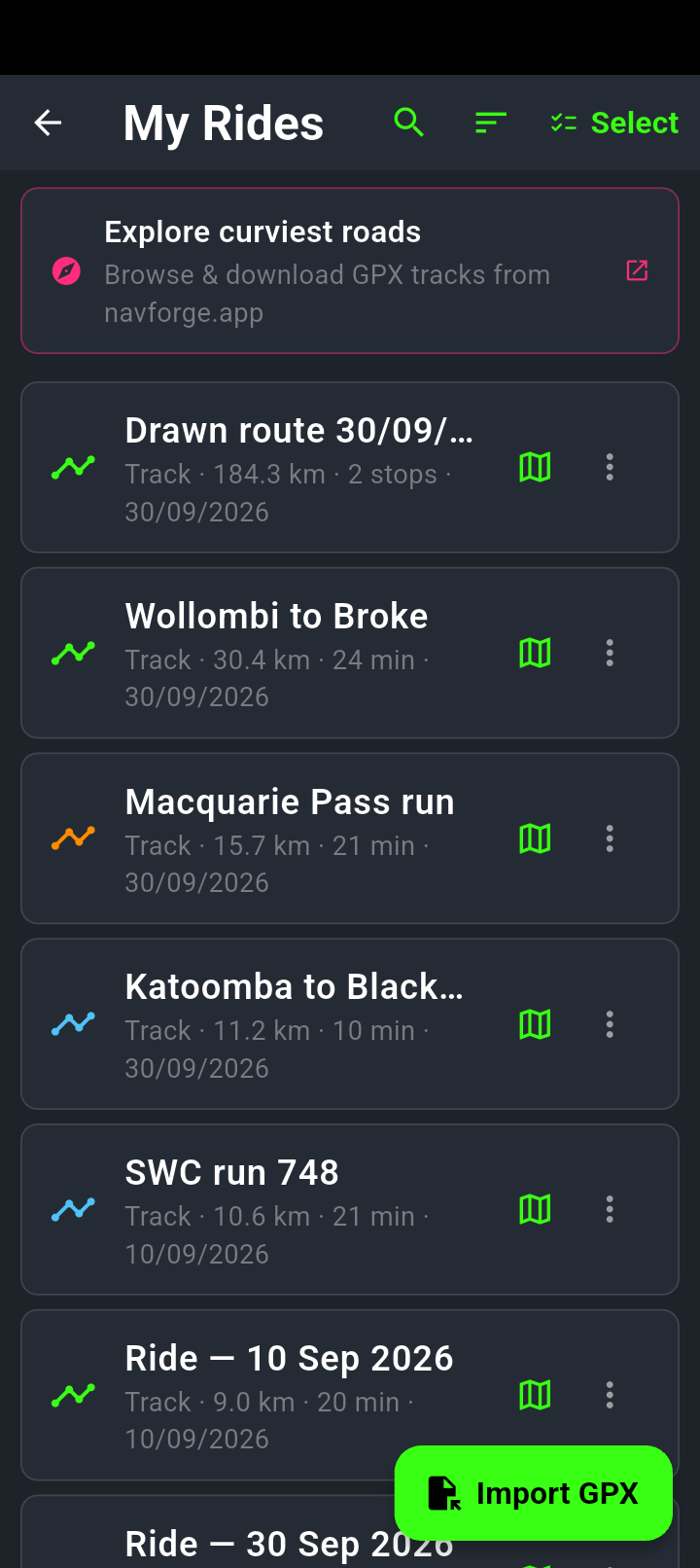
Recorded rides and imported files sit in one list, newest first. The line under each name tells you whether it’s a track or a route, how far it goes, and its date.
Select in the top right starts multi-select. Lower down, Removed from My Rides holds anything you have hidden, ready to restore.
Importing a GPX
Import GPX at the bottom right opens your phone’s file picker. The picker shows all your files, not only GPX — Android has no reliable file type for GPX, and a picker filtered to one would hide exactly the files you’re after, including anything downloaded from Gmail. So NavForge checks after you choose instead: pick something that isn’t a GPX and you’ll get Import cancelled or file unreadable and nothing is imported. Import is a premium feature — the button carries a padlock and turns amber when your subscription isn’t active.
Two things can happen before the import finishes:
- You’ve imported it before. The app compares the first coordinate of the incoming file against what you already have, so a file renamed by your browser or arriving as an email attachment is still recognised. You get Track already imported with Cancel and Replace.
- The route is outside your downloaded maps. You get Map not downloaded naming the region and its size. Choose the download and you’re taken to the download screen; choose Cancel and the import is thrown away.
Opening a GPX from another app
You don’t have to start from the picker. A GPX file anywhere on your phone can be handed straight to NavForge: tap the attachment in Gmail and choose Open with, or use Share from the Files app, Drive or anything else and pick NavForge from the list. The file is imported on the spot and a confirmation appears at the bottom of the screen — Imported: followed by the ride’s name. If the file turns out not to be a readable GPX, it says Could not read the shared GPX file instead.
NavForge’s own exports carry the whole ride — a timestamp, speed and lean angle on every point, and any hard-braking events. Import one and the ride is rebuilt exactly as it was recorded: duration, speeds and the analytics overlay all work, the same as on the original. A file from another app carries only the shape — coordinates and heights — so it can tell you distance and climb but not duration or speed, and the analytics overlay isn’t offered on it.
What the three dots offer
- Show on map — draws the ride over the map in green. Where a recording had auto-pause breaks, the stopped sections are drawn in grey so you can see where you sat still.
- Navigate this route — ride it again, covered below.
- Full stats — the numbers for that ride.
- Analytics overlay — the colour version, covered below.
- Rename — give the ride your own name. The new name follows the ride onto the calendar and into Full stats.
- Colour tag — pick one of six colours (or none) and the ride’s icon takes it, so your regular loops stand out in the list. Sort by Colour groups them.
- Export GPX — hands the file to Android’s share sheet, so it can go to email, a messaging app or your cloud drive.
- Export KML — the same ride as a Google Earth file: the line plus a pin for each stop.
- Export CSV — one row per point (position, height, time, speed, lean angle) for a spreadsheet.
- Plan for a date — pins it to a date on the calendar so you can load it on the day.
- Delete — confirms first, and from this screen it removes the ride from the list rather than destroying it (see below).
The same eleven actions follow the ride wherever it appears — a ride’s card on the calendar carries the identical set. The one that comes and goes is the analytics overlay: it needs the lean and speed readings, so it only appears on rides NavForge recorded itself and on imports of NavForge’s own exports.
Importing a file, navigating a ride, renaming it and tagging it with a colour are free. The three exports, plan-for-a-date and the analytics overlay are premium, and each carries a padlock in the menu when your subscription isn’t active.
Finding a ride in a long list
Every row shows the ride’s type, distance, riding time and date, and a plan shows how many stops it has. Beside each row a green map icon draws it straight away — the same as tapping the row, just easier to hit with a glove on.
At the top of the screen the magnifier opens a search box that narrows the list as you type part of a name. Next to it the sort control offers Newest first, Oldest first, Name, Longest first, Nearest to me and Colour — Nearest to me puts the rides that start closest to where you are now at the top, which is the quick way to find the loop you did from this spot last time. Your choice is remembered. New recordings are named by the day they were ridden, like Sunday ride 27/09/26, so the list reads the way you remember the rides.
A ride you removed isn’t gone
Removing a ride from the list hides it rather than destroying it. At the bottom of My Rides sits a collapsed row reading Removed from My Rides (2) with a Show control; open it and each hidden ride carries a Restore button that puts it straight back.
The Undo that appears when you remove a ride only lasts a few seconds. Before this section existed, missing it made the removal permanent as far as the list was concerned. The ride now waits there until you either restore it or delete it properly.
The menu’s Delete opens a box headed Remove from My Rides, and it tells you what it is really doing: It stays on your calendar — open the day and tap “Navigate this route” to ride it again. The ride leaves the list and waits in the removed section.
A ride is only destroyed from the other end: open it on the calendar and use Delete there, which warns This deletes the ride from My Rides too before it acts. That one cannot be undone.
Tidying up several at once
Deleting rides one at a time gets old quickly. Long-press any row to go into selection mode, then either tap rows individually or drag your finger down the list to sweep through a run of them — keep going past the bottom edge and the list scrolls along with you.
At the top you get Select all (which becomes Select none once everything is ticked) with a count of how many items there are. GPS debug logs can be selected the same way, and they can be cleared out even when you have no saved rides at all — which used to be impossible, because the controls only appeared alongside a ride.
Before you’ve recorded anything, My Rides offers a Start Recording button rather than an empty screen. It genuinely starts a recording — for a while it only closed the screen without recording anything.
Drawing a route with a finger
Open the menu and tap Draw a route. The map stops panning and your finger becomes a pen: drag it along the roads you want to ride and a green line follows, with the distance drawn ticking in the bar at the bottom. Lift and touch again to keep going; Undo takes back the last stroke; Cancel throws the drawing away.
Tap Done and the app snaps the whole line to the road network in one go — it doesn’t need to be neat, a rough scribble along the highway is enough — then saves it in My Rides as Drawn route with the day’s date, shows it on the map and offers Navigate. From then on it’s an ordinary ride: rename it, colour it, export it, plan it for a date, ride it. If nothing under the line is a road (across water, say), the drawing stays on screen and the app tells you, so you can move it and try again.
Zoomed right out for a day’s ride — Sydney to Orange on one screen, say — the line can’t follow every street, so the app keeps its corners and routes between them the way it routes between the stops you type; the corners become the ride’s stops. The website planner at plan.navforge.app has the same Draw a route button: drag with the mouse or a finger, lift, and the corners become your stops there too.
Riding a saved route again
Tap Navigate this route and a card appears first, showing the trip and working out where you’re standing relative to it. The buttons on the card change with your position, so you’re choosing what happens rather than being guessed at:
The same card is what you get mid-recording when you press and hold the record button: it shows the ride so far and offers Reverse the trip, which takes you back along your own track. See Recording a ride.
-
At the start of the ride
Start Navigation follows the recorded line exactly — the same corners, the same dirt detour, the same wrong turn you decided you liked. Nothing is re-planned, so nothing gets smoothed onto the nearest sealed road. If the ride is a loop that starts and ends where you are, the button reads Start loop.
-
Away from the start — beyond about half a kilometre
Start Navigation gives you road guidance to the start of the ride first. Once you’re within about a hundred metres of it, the app swaps over to the recorded line by itself and carries on. You don’t need to stop and tap anything again.
-
At the far end of the ride
The card offers Reverse the trip — the recorded line flipped end to end, so you ride it home the way you came. No re-planning here either.
-
Somewhere along the middle of it
You get Pick up from here, which joins the ride at the closest point to you and follows the rest of it, or Route to trip start if you’d rather be guided back to the beginning and ride the whole thing.
Cancel on the card closes it and nothing else happens. If the route worked out to reach the start is much longer or much shorter than the ride itself, you’ll see Route differs from track explaining the two distances, with Navigate anyway if you’re happy. A file with fewer than two usable points gives Track too short to navigate.
The analytics overlay
This one needs the lean and speed readings that only NavForge writes, so it appears on rides NavForge recorded — and on imports of NavForge’s own exports, which carry those readings with them. Files from other apps don’t have them, so it isn’t offered there. It redraws the ride in three colours:
- Green — under 15° of lean and under 60 km/h.
- Amber — 15° to 35° of lean, or 60 to 100 km/h.
- Red — over 35° of lean, or over 100 km/h.
A warning marker is dropped at every hard-braking event, and a panel over the map gives you max and average lean, max and average speed, the number of hard brakes, total climb, the hardest braking force and the ride duration.
Speed alone can turn a section red without you leaning at all, so a stretch of motorway shows up the same colour as a hard corner. Read the two numbers together rather than treating the colour as a score.
Tidying up
The tick-list icon in the top bar — or a long press on any row — puts the list into selection mode. Tick as many rides and logs as you like and the top bar offers Delete (3), with a confirmation that spells out what’s about to go. It cannot be undone.
Underneath your rides you may see a GPS DEBUG LOGS section. These are plain text files the app writes for itself — a fresh one each time you open NavForge, whether or not you record anything. They are what makes a problem report useful, so if something went wrong on a ride, the log from that session is the thing to send. Share CSV sends one on; deleting them doesn’t touch your rides.
A shared GPX opens in almost anything else — so if you’re clearing space but the ride mattered, send it to yourself first.